
Make a donation
Gear up for your next adventure:
As an Amazon Associate, this site earns from qualifying purchases at no extra cost to you.
Quarten topographic map
Click on the map to display elevation.
Make a donation
Gear up for your next adventure:
As an Amazon Associate, this site earns from qualifying purchases at no extra cost to you.
Quarten
The settlements of Murg, Unterterzen and Mols lie along the southern shoreline of the Walensee, overlooked by Quarten and Oberterzen at a slightly higher altitude. The hamlet of Quinten lies on the north shore of the Walensee, and is only accessible by boat or on foot. Tannenbodenalp lies some 1,100 metres (3,600 ft) above Unterterzen, forming part of the Flumserberg ski resort, and is split between the municipalities of Quarten and Flums.
Make a donation
Gear up for your next adventure:
As an Amazon Associate, this site earns from qualifying purchases at no extra cost to you.
About this map
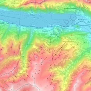
Name: Quarten topographic map, elevation, terrain.
Location: Quarten, Wahlkreis Sarganserland, St. Gallen, Switzerland (47.02592 9.13806 47.14871 9.30368)
Average elevation: 4,209 ft
Minimum elevation: 1,365 ft
Maximum elevation: 8,169 ft
Make a donation
Gear up for your next adventure:
As an Amazon Associate, this site earns from qualifying purchases at no extra cost to you.