
Make a donation
Gear up for your next adventure:
As an Amazon Associate, this site earns from qualifying purchases at no extra cost to you.
La Fouly topographic map
Click on the map to display elevation.
Make a donation
Gear up for your next adventure:
As an Amazon Associate, this site earns from qualifying purchases at no extra cost to you.
About this map
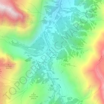
Name: La Fouly topographic map, elevation, terrain.
Location: La Fouly, Orsières, Entremont, Wallis, 2303, Schweiz (45.91312 7.07897 45.95312 7.11897)
Average elevation: 6,578 ft
Minimum elevation: 4,777 ft
Maximum elevation: 9,902 ft
Make a donation
Gear up for your next adventure:
As an Amazon Associate, this site earns from qualifying purchases at no extra cost to you.
Other topographic maps
Click on a map to view its topography, its elevation and its terrain.
Orsières
In Orsières verzweigen sich zwei Alpentäler: Durch das Val d’Entremont führt die Schweizer Hauptstrasse 21 als Nordrampe zum Grossen St. Bernhard (2429 m ü. M.) und schliesst an die italienische Strada Statale 27 del Gran San Bernardo im Aostatal an, während sich das Val Ferret im Südwesten des…
Average elevation: 7,648 ft
Liddes
Die Gemeinde liegt an der Hauptstrasse 21 zum Grossen Sankt Bernhard als zweitletztes Dorf vor der Passhöhe. Sie grenzt im Norden an Orsières, im Osten an Val de Bagnes und im Süden an Bourg-Saint-Pierre und besteht neben Liddes-Ville aus den Weilern Chandonne, Dranse, Rive-Haute, Fontaine-Dessous,…
Average elevation: 6,965 ft
Make a donation
Gear up for your next adventure:
As an Amazon Associate, this site earns from qualifying purchases at no extra cost to you.