Geolocate

Arnold topographic map

Click on the map to display elevation.

About this map

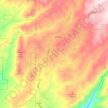
Name: Arnold topographic map, elevation, terrain.

Location: Arnold, Calaveras County, California, United States (38.20457 -120.41123 38.27966 -120.30548)

Average elevation: 3,842 ft

Minimum elevation: 2,136 ft

Maximum elevation: 5,003 ft

Calaveras County trails, hiking, mountain biking, running and outdoor activities

Other topographic maps

Click on a map to view its topography, its elevation and its terrain.

Manuel Mill

United States > California > Calaveras County > Arnold

Average elevation: 4,032 ft

Manuel Mill

United States > California > Calaveras County > Arnold

Average elevation: 4,032 ft

Gear up for your next adventure:

🪓Survival Multi‑Tool - Versatile tool for camp and trail tasks
❄️Traction Cleats - Prevent slips on icy trails during winter hikes
🔦LED Headlamp - Bright and durable LED headlamp for night navigation
🖼️Topo Map Wall Art - Decorative topographic prints of famous peaks and regions
🗺️NatGeo Topo Maps - High-quality waterproof printed topographic maps of US Parks

As an Amazon Associate, this site earns from qualifying purchases at no extra cost to you.