
Make a donation
Gear up for your next adventure:
As an Amazon Associate, this site earns from qualifying purchases at no extra cost to you.
Richelle topographic map
Click on the map to display elevation.
Make a donation
Gear up for your next adventure:
As an Amazon Associate, this site earns from qualifying purchases at no extra cost to you.
Richelle
Richelle ligt, op een hoogte van ongeveer 120 meter, aan de rechteroever van de Maas tussen Luik en Wezet. Ook ligt het aan de weg van Argenteau naar Dalhem die vanuit Argenteau een kronkelend en steil verloop heeft en aan de spoorlijn tussen Luik en Maastricht. Richelle behoort tot de uiterste westrand van het Land van Herve met zijn typische weilanden en boomgaarden.
Make a donation
Gear up for your next adventure:
As an Amazon Associate, this site earns from qualifying purchases at no extra cost to you.
About this map
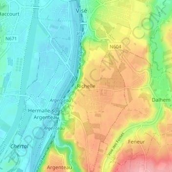
Name: Richelle topographic map, elevation, terrain.
Location: Richelle, Wezet, Luik, Wallonië, 4600, België (50.69714 5.67535 50.73714 5.71535)
Average elevation: 308 ft
Minimum elevation: 171 ft
Maximum elevation: 545 ft
Make a donation
Gear up for your next adventure:
As an Amazon Associate, this site earns from qualifying purchases at no extra cost to you.