
Make a donation
Gear up for your next adventure:
As an Amazon Associate, this site earns from qualifying purchases at no extra cost to you.
Yanahuanca topographic map
Click on the map to display elevation.
Make a donation
Gear up for your next adventure:
As an Amazon Associate, this site earns from qualifying purchases at no extra cost to you.
About this map
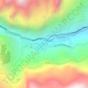
Name: Yanahuanca topographic map, elevation, terrain.
Location: Yanahuanca, Daniel Alcides Carrión, Pasco, Peru (-10.49389 -76.52189 -10.48903 -76.50594)
Average elevation: 11,598 ft
Minimum elevation: 10,062 ft
Maximum elevation: 13,501 ft
Make a donation
Gear up for your next adventure:
As an Amazon Associate, this site earns from qualifying purchases at no extra cost to you.
Other topographic maps
Click on a map to view its topography, its elevation and its terrain.
Cerro de Pasco
Localizada a 4.338 m de altitude, é uma das mais altas cidades do mundo. O clima é de alta montanha, com temperaturas entre 10 graus e -4 graus Celsius e neve ocasional.
Average elevation: 13,907 ft