
Make a donation
Gear up for your next adventure:
As an Amazon Associate, this site earns from qualifying purchases at no extra cost to you.
Champoussin topographic map
Click on the map to display elevation.
Make a donation
Gear up for your next adventure:
As an Amazon Associate, this site earns from qualifying purchases at no extra cost to you.
About this map
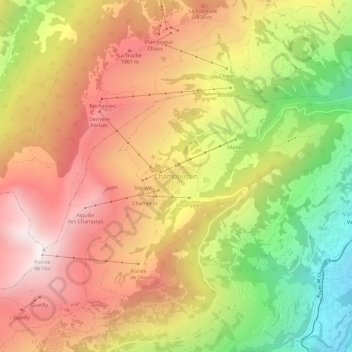
Name: Champoussin topographic map, elevation, terrain.
Location: Champoussin, Val-d'Illiez, Monthey, Wallis, 1873, Schweiz (46.18829 6.84285 46.22829 6.88285)
Average elevation: 5,157 ft
Minimum elevation: 2,838 ft
Maximum elevation: 7,051 ft
Make a donation
Gear up for your next adventure:
As an Amazon Associate, this site earns from qualifying purchases at no extra cost to you.
Other topographic maps
Click on a map to view its topography, its elevation and its terrain.
Lac Vert
Schweiz > Wallis > Monthey > Val-d'Illiez
Der See liegt auf einer Höhe von 1974 Metern in der Region Chablais im Kanton Wallis, auf dem Gebiet der Gemeinde Val-d’Illiez.
Average elevation: 6,339 ft