
Charco Zarco topographic map
Interactive map
Click on the map to display elevation.
About this map
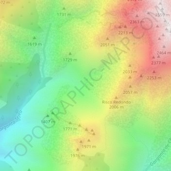
Name: Charco Zarco topographic map, elevation, terrain.
Location: Charco Zarco, Candeleda, Ávila, Castille-et-León, Espagne (40.22680 -5.32541 40.24680 -5.30541)
Average elevation: 5,689 ft
Minimum elevation: 3,717 ft
Maximum elevation: 8,327 ft
Other topographic maps
Click on a map to view its topography, its elevation and its terrain.
Monte Patón
Espagne > Castille-et-León > Candeleda
Monte Patón, Candeleda, Comarca de Arenas de San Pedro, Ávila, Castille-et-León, 05489, Espagne
Average elevation: 3,753 ft