
Monte Patón topographic map
Interactive map
Click on the map to display elevation.
About this map
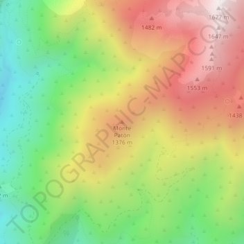
Name: Monte Patón topographic map, elevation, terrain.
Average elevation: 3,753 ft
Minimum elevation: 2,188 ft
Maximum elevation: 5,472 ft
Other topographic maps
Click on a map to view its topography, its elevation and its terrain.
Charco Zarco
Espagne > Castille-et-León > Candeleda
Charco Zarco, Candeleda, Ávila, Castille-et-León, Espagne
Average elevation: 5,689 ft