
Wanship topographic map
Click on the map to display elevation.
About this map
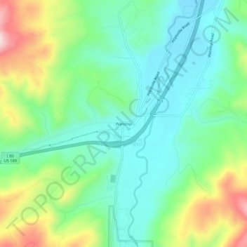
Name: Wanship topographic map, elevation, terrain.
Location: Wanship, Summit County, Utah, United States (40.79176 -111.42734 40.83176 -111.38734)
Average elevation: 6,135 ft
Minimum elevation: 5,781 ft
Maximum elevation: 6,913 ft
Summit County trails, hiking, mountain biking, running and outdoor activities
Other topographic maps
Click on a map to view its topography, its elevation and its terrain.
Oakley
United States > Utah > Summit County
Oakley is located 45 miles (72 km) east of Salt Lake City on SR-32, in the Kamas Valley. With an elevation of 6,500 feet (2,000 m), it is a gateway to the Uinta Mountains. Scenic route Weber Canyon Road follows the Weber River to its headwaters; it also follows the Smith and Morehouse Creek to its reservoir in…
Average elevation: 6,716 ft