
Make a donation
Gear up for your next adventure:
As an Amazon Associate, this site earns from qualifying purchases at no extra cost to you.
Cacheu Region topographic map
Click on the map to display elevation.
Make a donation
Gear up for your next adventure:
As an Amazon Associate, this site earns from qualifying purchases at no extra cost to you.
Cacheu Region
Cacheu is a low-lying coastal region and the low-lying coastal areas are periodically submerged during high tide. All the coastal regions have a maximum elevation of 300 m (980 ft). The internal region has plains, which are interspersed with rias. There are lot of meandering rivers, many of them forming estuaries in the coastal regions. The principal river, Cacheu, flows through the region. The climate is hot and tropical and the region has two seasons. The onset of summer is from December to May with April - May period having temperature ranges from 20 °C (68 °F) to 30 °C (86 °F). The rainy season is usually from May to November. The region receives an average rainfall of around 2,000 mm (79 in) compared to the inland regions, which receive 1,000 mm (39 in). The coastal regions are covered with Mangrove swamps, rain forest and tangled forest.
Make a donation
Gear up for your next adventure:
As an Amazon Associate, this site earns from qualifying purchases at no extra cost to you.
About this map
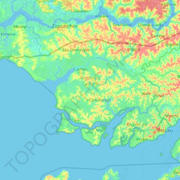
Name: Cacheu Region topographic map, elevation, terrain.
Location: Cacheu Region, Província Norte, Guinea-Bissau (11.74910 -16.71726 12.51534 -15.47995)
Average elevation: 23 ft
Minimum elevation: -10 ft
Maximum elevation: 154 ft
Make a donation
Gear up for your next adventure:
As an Amazon Associate, this site earns from qualifying purchases at no extra cost to you.
Other topographic maps
Click on a map to view its topography, its elevation and its terrain.
Make a donation
Gear up for your next adventure:
As an Amazon Associate, this site earns from qualifying purchases at no extra cost to you.