
Thank you for supporting this site ❤️
Make a donation
Make a donation
Gear up for your next adventure:
As an Amazon Associate, this site earns from qualifying purchases at no extra cost to you.
Project 4 topographic map
Click on the map to display elevation.
Thank you for supporting this site ❤️
Make a donation
Make a donation
Gear up for your next adventure:
As an Amazon Associate, this site earns from qualifying purchases at no extra cost to you.
About this map
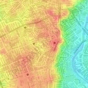
Name: Project 4 topographic map, elevation, terrain.
Average elevation: 135 ft
Minimum elevation: 7 ft
Maximum elevation: 203 ft
Thank you for supporting this site ❤️
Make a donation
Make a donation
Gear up for your next adventure:
As an Amazon Associate, this site earns from qualifying purchases at no extra cost to you.
Other topographic maps
Click on a map to view its topography, its elevation and its terrain.
La Mesa Eco Park
Covering an area of 33 hectares (82 acres) the public park is located along the natural boundary of the La Mesa Watershed Reservation and its elevation is about 40 metres (130 ft) below than the resorvoir.
Average elevation: 217 ft