
上栗县 topographic map
Interactive map
Click on the map to display elevation.
About this map
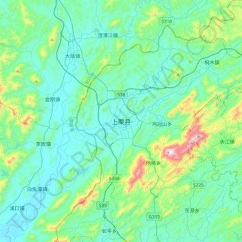
Name: 上栗县 topographic map, elevation, terrain.
Location: 上栗县, 萍乡市, 江西省, 中国 (27.72355 113.63095 28.04355 113.95095)
Average elevation: 663 ft
Minimum elevation: 190 ft
Maximum elevation: 2,982 ft
全县地形以丘陵、山地为主,属罗霄山餘脉。地势东北高,西南低。全县平均高度为海拔233.7米。
Other topographic maps
Click on a map to view its topography, its elevation and its terrain.