
Jochiwon-eup topographic map
Interactive map
Click on the map to display elevation.
About this map
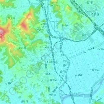
Name: Jochiwon-eup topographic map, elevation, terrain.
Location: Jochiwon-eup, Sejong, South Korea (36.57805 127.25842 36.63645 127.30659)
Average elevation: 161 ft
Minimum elevation: 52 ft
Maximum elevation: 755 ft
Other topographic maps
Click on a map to view its topography, its elevation and its terrain.
Yeongi-myeon
South Korea > Sejong > Yeongi-myeon
Yeongi-myeon, Sejong, South Korea
Average elevation: 207 ft
Garam-dong
South Korea > Sejong > Hansol-dong
Garam-dong, Hansol-dong, Sejong, 30065, South Korea
Average elevation: 75 ft