Geolocate

D'Ran topographic map

Click on the map to display elevation.

About this map
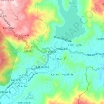
Name: D'Ran topographic map, elevation, terrain.

Location: D'Ran, Xã D'Ran, Lâm Đồng Province, Vietnam (11.80325 108.55795 11.88325 108.63795)

Average elevation: 3,855 ft

Minimum elevation: 3,186 ft

Maximum elevation: 5,407 ft

Other topographic maps

Click on a map to view its topography, its elevation and its terrain.
Đập Đa Nhim

Vietnam > Lâm Đồng Province > Xã D'Ran > D'Ran

Average elevation: 3,468 ft

Gear up for your next adventure:

💧Water Filtration Bottles - Safely drink from streams and lakes while exploring
🧯Emergency Survival Kit - All‑in‑one survival essentials for the backcountry
🔊Portable Camp Speaker - Music and alerts at camp
🔪Outdoor Multitools - Essential survival tools for gear repair and field use
🧢Sun Protection Hats - Wide-brimmed and UPF-rated hats for high-altitude sun safety

As an Amazon Associate, this site earns from qualifying purchases at no extra cost to you.