
Thank you for supporting this site ❤️
Make a donation
Make a donation
Gear up for your next adventure:
As an Amazon Associate, this site earns from qualifying purchases at no extra cost to you.
D'Ran topographic map
Click on the map to display elevation.
Thank you for supporting this site ❤️
Make a donation
Make a donation
Gear up for your next adventure:
As an Amazon Associate, this site earns from qualifying purchases at no extra cost to you.
About this map
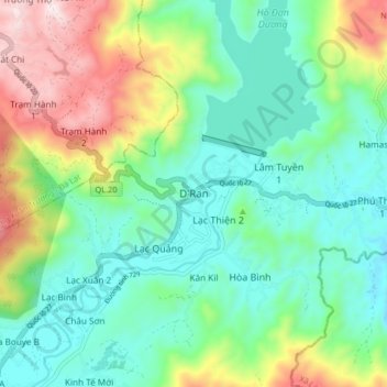
Name: D'Ran topographic map, elevation, terrain.
Location: D'Ran, Xã D'Ran, Lâm Đồng Province, Vietnam (11.80325 108.55795 11.88325 108.63795)
Average elevation: 3,855 ft
Minimum elevation: 3,186 ft
Maximum elevation: 5,407 ft
Thank you for supporting this site ❤️
Make a donation
Make a donation
Gear up for your next adventure:
As an Amazon Associate, this site earns from qualifying purchases at no extra cost to you.
Other topographic maps
Click on a map to view its topography, its elevation and its terrain.