Geolocate

Musselburgh topographic map

Click on the map to display elevation.

About this map

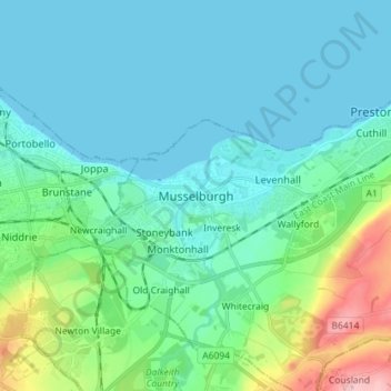
Name: Musselburgh topographic map, elevation, terrain.

Location: Musselburgh, East Lothian, Scotland, EH21 7DX, United Kingdom (55.90212 -3.09385 55.98212 -3.01385)

Average elevation: 105 ft

Minimum elevation: 0 ft

Maximum elevation: 564 ft

Gear up for your next adventure:

🥇GPS Hiking Watch - Multi‑sport GPS watch with navigation and trail tracking
🕶️GPS Smartphone Mount - Secure mount for phone navigation
📱Solar Portable Charger - Solar power bank for charging devices off‑grid
🩳Quick‑Dry Hiking Shorts - Comfortable and quick‑dry shorts for summer hiking
🗃️Trail First Aid Kit - Essential kit for outdoor injuries and emergencies

As an Amazon Associate, this site earns from qualifying purchases at no extra cost to you.