
Thank you for supporting this site ❤️
Make a donation
Make a donation
Gear up for your next adventure:
As an Amazon Associate, this site earns from qualifying purchases at no extra cost to you.
Rauco topographic map
Click on the map to display elevation.
Thank you for supporting this site ❤️
Make a donation
Make a donation
Gear up for your next adventure:
As an Amazon Associate, this site earns from qualifying purchases at no extra cost to you.
About this map
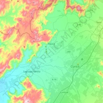
Name: Rauco topographic map, elevation, terrain.
Location: Rauco, Provincia de Curicó, Maule Region, Chile (-35.05767 -71.59871 -34.83303 -71.26027)
Average elevation: 984 ft
Minimum elevation: 374 ft
Maximum elevation: 2,552 ft
Thank you for supporting this site ❤️
Make a donation
Make a donation
Gear up for your next adventure:
As an Amazon Associate, this site earns from qualifying purchases at no extra cost to you.