Geolocate

Petrich topographic map

Click on the map to display elevation.

About this map

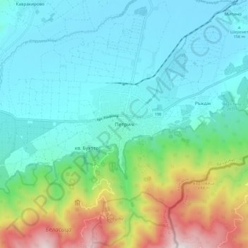
Name: Petrich topographic map, elevation, terrain.

Location: Petrich, Blagoevgrad, 2850, Bulgaria (41.35529 23.16678 41.43529 23.24678)

Average elevation: 1,093 ft

Minimum elevation: 292 ft

Maximum elevation: 3,698 ft

Other topographic maps

Click on a map to view its topography, its elevation and its terrain.

Рупите

Bulgaria > Blagoevgrad

Average elevation: 384 ft

Тевно езеро

Bulgaria > Blagoevgrad

Average elevation: 7,969 ft

Frog lake

Bulgaria > Blagoevgrad

Average elevation: 7,907 ft

Gear up for your next adventure:

🕶️GPS Smartphone Mount - Secure mount for phone navigation
🧢Sun Protection Hats - Wide-brimmed and UPF-rated hats for high-altitude sun safety
🎒Day Hiking Backpack - Lightweight backpack perfect for day trips and outdoor adventures
🌄Hiking Binoculars - Compact binoculars for scenic views and trail spotting
🧣Hiking Neck Gaiter - Multi‑use neck protection for outdoor weather

As an Amazon Associate, this site earns from qualifying purchases at no extra cost to you.