
Haus topographic map
Click on the map to display elevation.
About this map
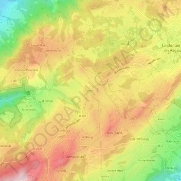
Name: Haus topographic map, elevation, terrain.
Location: Haus, Scheidegg, Landkreis Lindau, Bayern, 88175, Deutschland (47.57210 9.83944 47.61210 9.87944)
Average elevation: 2,536 ft
Minimum elevation: 1,962 ft
Maximum elevation: 2,989 ft
Other topographic maps
Click on a map to view its topography, its elevation and its terrain.