Geolocate

Calonge topographic map

Click on the map to display elevation.

About this map

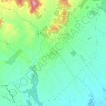
Name: Calonge topographic map, elevation, terrain.

Location: Calonge, Santanyí, Migjorn, Balearic Islands, 07669, Spain (39.38074 3.18400 39.42074 3.22400)

Average elevation: 269 ft

Minimum elevation: 56 ft

Maximum elevation: 820 ft

Gear up for your next adventure:

🧭Outdoor Navigation Book - Learn advanced navigation skills
🧺Microfiber Travel Towels - Compact and fast-drying towels for trail use
🧢Outdoor Hiking Hat - Sun protection hat for outdoor explorers
🌐World Map Poster - Decorative world maps with topographic info
🎒Trail Energy Bars - High‑calorie bars for hiking energy

As an Amazon Associate, this site earns from qualifying purchases at no extra cost to you.