
Thank you for supporting this site ❤️
Make a donation
Make a donation
Gear up for your next adventure:
As an Amazon Associate, this site earns from qualifying purchases at no extra cost to you.
N'Gaous topographic map
Click on the map to display elevation.
Thank you for supporting this site ❤️
Make a donation
Make a donation
Gear up for your next adventure:
As an Amazon Associate, this site earns from qualifying purchases at no extra cost to you.
N'Gaous
La ville de N'Gaous se situe dans une région montagneuse, à 770 m d'altitude, proche du massif montagneux de Belezma.
Thank you for supporting this site ❤️
Make a donation
Make a donation
Gear up for your next adventure:
As an Amazon Associate, this site earns from qualifying purchases at no extra cost to you.
About this map
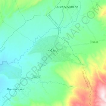
Name: N'Gaous topographic map, elevation, terrain.
Location: N'Gaous, Daïra N'Gaous, Batna, 05600, Algérie (35.50267 5.50502 35.59991 5.67134)
Average elevation: 2,703 ft
Minimum elevation: 2,047 ft
Maximum elevation: 5,112 ft
Thank you for supporting this site ❤️
Make a donation
Make a donation
Gear up for your next adventure:
As an Amazon Associate, this site earns from qualifying purchases at no extra cost to you.