
Mariakerke topographic map
Interactive map
Click on the map to display elevation.
About this map
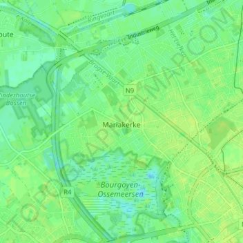
Name: Mariakerke topographic map, elevation, terrain.
Location: Mariakerke, Gent, Oost-Vlaanderen, 9030, België (51.05318 3.65758 51.09320 3.70671)
Average elevation: 23 ft
Minimum elevation: -26 ft
Maximum elevation: 36 ft
Other topographic maps
Click on a map to view its topography, its elevation and its terrain.
Zwijnaarde
België > Oost-Vlaanderen > Gent > Gent
Zwijnaarde, Gent, Oost-Vlaanderen, Vlaanderen, 9052, België
Average elevation: 30 ft
Sint-Amandsberg
België > Oost-Vlaanderen > Gent > Gent
Sint-Amandsberg, Gent, Oost-Vlaanderen, Vlaanderen, 9040, België
Average elevation: 26 ft
Gent
België > Oost-Vlaanderen > Gent > Gent
Gent, Oost-Vlaanderen, Vlaanderen, 24-32, België
Average elevation: 39 ft
Drongen
België > Oost-Vlaanderen > Gent > Gent
Drongen, Gent, Oost-Vlaanderen, Vlaanderen, 9031, België
Average elevation: 23 ft
Westelijke Leie
België > Oost-Vlaanderen > Gent > Gent
Westelijke Leie, Gent, Oost-Vlaanderen, Vlaanderen, 9000, België
Average elevation: 26 ft
Groenzone Scandinaviëstraat
België > Oost-Vlaanderen > Gent > Gent
Groenzone Scandinaviëstraat, Muide, Gent, Oost-Vlaanderen, Vlaanderen, België
Average elevation: 26 ft