
Thank you for supporting this site ❤️
Make a donation
Make a donation
Gear up for your next adventure:
As an Amazon Associate, this site earns from qualifying purchases at no extra cost to you.
Casca topographic map
Click on the map to display elevation.
Thank you for supporting this site ❤️
Make a donation
Make a donation
Gear up for your next adventure:
As an Amazon Associate, this site earns from qualifying purchases at no extra cost to you.
About this map
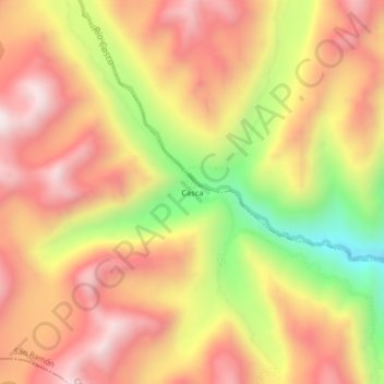
Name: Casca topographic map, elevation, terrain.
Location: Casca, San Ramón, Chanchamayo, Junín, Perú (-11.15792 -75.62097 -11.11792 -75.58097)
Average elevation: 12,375 ft
Minimum elevation: 10,751 ft
Maximum elevation: 13,484 ft
Thank you for supporting this site ❤️
Make a donation
Make a donation
Gear up for your next adventure:
As an Amazon Associate, this site earns from qualifying purchases at no extra cost to you.