
Make a donation
Gear up for your next adventure:
As an Amazon Associate, this site earns from qualifying purchases at no extra cost to you.
Park Hills topographic map
Click on the map to display elevation.
Make a donation
Gear up for your next adventure:
As an Amazon Associate, this site earns from qualifying purchases at no extra cost to you.
About this map
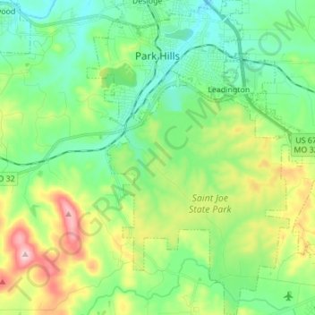
Name: Park Hills topographic map, elevation, terrain.
Location: Park Hills, Saint Francois County, Missouri, United States (37.76274 -90.55358 37.87104 -90.45598)
Average elevation: 948 ft
Minimum elevation: 696 ft
Maximum elevation: 1,535 ft
Saint Francois County trails, hiking, mountain biking, running and outdoor activities
Make a donation
Gear up for your next adventure:
As an Amazon Associate, this site earns from qualifying purchases at no extra cost to you.
Other topographic maps
Click on a map to view its topography, its elevation and its terrain.
Make a donation
Gear up for your next adventure:
As an Amazon Associate, this site earns from qualifying purchases at no extra cost to you.
The Lead Belt
United States > Missouri > Saint Francois County > Bonne Terre
Average elevation: 843 ft