
Make a donation
Gear up for your next adventure:
As an Amazon Associate, this site earns from qualifying purchases at no extra cost to you.
Ashley River topographic map
Click on the map to display elevation.
Make a donation
Gear up for your next adventure:
As an Amazon Associate, this site earns from qualifying purchases at no extra cost to you.
About this map
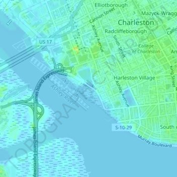
Name: Ashley River topographic map, elevation, terrain.
Average elevation: 10 ft
Minimum elevation: -7 ft
Maximum elevation: 52 ft
Charleston County trails, hiking, mountain biking, running and outdoor activities
Make a donation
Gear up for your next adventure:
As an Amazon Associate, this site earns from qualifying purchases at no extra cost to you.
Other topographic maps
Click on a map to view its topography, its elevation and its terrain.
Hibernian Heights
United States > South Carolina > Charleston County > Charleston
Average elevation: 10 ft
Stafford Heights
United States > South Carolina > Charleston County > Charleston
Average elevation: 16 ft
Make a donation
Gear up for your next adventure:
As an Amazon Associate, this site earns from qualifying purchases at no extra cost to you.
Forest Acres West
United States > South Carolina > Charleston County > Charleston
Average elevation: 16 ft
Make a donation
Gear up for your next adventure:
As an Amazon Associate, this site earns from qualifying purchases at no extra cost to you.
Grove Creek Village
United States > South Carolina > Charleston County > Charleston
Average elevation: 10 ft
Saint Andrews
United States > South Carolina > Charleston County > Charleston
Average elevation: 10 ft
Make a donation
Gear up for your next adventure:
As an Amazon Associate, this site earns from qualifying purchases at no extra cost to you.
Hickory Hall Plantation
United States > South Carolina > Charleston County > Charleston
Average elevation: 16 ft
Ashley Hall Manor
United States > South Carolina > Charleston County > Charleston
Average elevation: 16 ft
Harrison Acres
United States > South Carolina > Charleston County > Charleston
Average elevation: 13 ft
Make a donation
Gear up for your next adventure:
As an Amazon Associate, this site earns from qualifying purchases at no extra cost to you.
Oakcrest
United States > South Carolina > Charleston County > Charleston > Oakcrest
Average elevation: 13 ft
Seaside
United States > South Carolina > Charleston County > Charleston > Seaside
Average elevation: 7 ft
Wragg Borough Homes
United States > South Carolina > Charleston County > Charleston > Wragg Borough Homes
Average elevation: 10 ft
Maryville
United States > South Carolina > Charleston County > Charleston > Maryville
Average elevation: 13 ft
Make a donation
Gear up for your next adventure:
As an Amazon Associate, this site earns from qualifying purchases at no extra cost to you.
Fenwick Crossroads
United States > South Carolina > Charleston County > Charleston > Fenwick Crossroads
Average elevation: 16 ft