
Thank you for supporting this site ❤️
Make a donation
Make a donation
Gear up for your next adventure:
As an Amazon Associate, this site earns from qualifying purchases at no extra cost to you.
Sumpong topographic map
Click on the map to display elevation.
Thank you for supporting this site ❤️
Make a donation
Make a donation
Gear up for your next adventure:
As an Amazon Associate, this site earns from qualifying purchases at no extra cost to you.
About this map
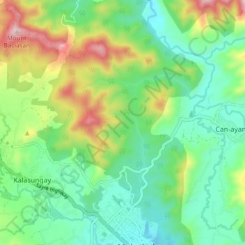
Name: Sumpong topographic map, elevation, terrain.
Location: Sumpong, Bukidnon, Northern Mindanao, Philippines (8.15557 125.11155 8.22126 125.15047)
Average elevation: 2,451 ft
Minimum elevation: 1,962 ft
Maximum elevation: 3,497 ft
Thank you for supporting this site ❤️
Make a donation
Make a donation
Gear up for your next adventure:
As an Amazon Associate, this site earns from qualifying purchases at no extra cost to you.