
Thank you for supporting this site ❤️
Make a donation
Make a donation
Gear up for your next adventure:
As an Amazon Associate, this site earns from qualifying purchases at no extra cost to you.
Mücka topographic map
Click on the map to display elevation.
Thank you for supporting this site ❤️
Make a donation
Make a donation
Gear up for your next adventure:
As an Amazon Associate, this site earns from qualifying purchases at no extra cost to you.
About this map
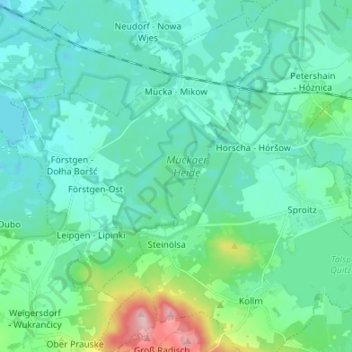
Name: Mücka topographic map, elevation, terrain.
Location: Mücka, Diehsa, Görlitz, Sachsen, Deutschland (51.25436 14.63665 51.33834 14.73576)
Average elevation: 531 ft
Minimum elevation: 436 ft
Maximum elevation: 981 ft
Thank you for supporting this site ❤️
Make a donation
Make a donation
Gear up for your next adventure:
As an Amazon Associate, this site earns from qualifying purchases at no extra cost to you.