Geolocate

Battle topographic map

Click on the map to display elevation.

About this map

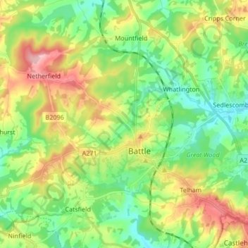
Name: Battle topographic map, elevation, terrain.

Location: Battle, Rother, East Sussex, England, United Kingdom (50.89211 0.41181 50.96093 0.54624)

Average elevation: 217 ft

Minimum elevation: 26 ft

Maximum elevation: 541 ft

Other topographic maps

Click on a map to view its topography, its elevation and its terrain.

Great Beech

United Kingdom > England > East Sussex > Rother > Battle

Average elevation: 253 ft

Gear up for your next adventure:

🪶Paracord Bracelet - Survival bracelet with built‑in tools
📦Dry Bags Set - Waterproof storage for electronics and clothes
🗃️Trail First Aid Kit - Essential kit for outdoor injuries and emergencies
🔭Telescopic Hiking Pole - Adjustable pole for hiking stability
❄️Traction Cleats - Prevent slips on icy trails during winter hikes

As an Amazon Associate, this site earns from qualifying purchases at no extra cost to you.