
Thank you for supporting this site ❤️
Make a donation
Make a donation
Gear up for your next adventure:
As an Amazon Associate, this site earns from qualifying purchases at no extra cost to you.
Bad Schussenried topographic map
Click on the map to display elevation.
Thank you for supporting this site ❤️
Make a donation
Make a donation
Gear up for your next adventure:
As an Amazon Associate, this site earns from qualifying purchases at no extra cost to you.
About this map
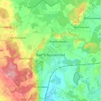
Name: Bad Schussenried topographic map, elevation, terrain.
Average elevation: 1,962 ft
Minimum elevation: 1,778 ft
Maximum elevation: 2,320 ft
Thank you for supporting this site ❤️
Make a donation
Make a donation
Gear up for your next adventure:
As an Amazon Associate, this site earns from qualifying purchases at no extra cost to you.
Other topographic maps
Click on a map to view its topography, its elevation and its terrain.
Bergerhausen
Germany > Baden-Württemberg > Landkreis Biberach > Biberach an der Riß
Average elevation: 1,900 ft
Orsenhausen
Germany > Baden-Württemberg > Landkreis Biberach > Orsenhausen
Average elevation: 1,785 ft