
Thank you for supporting this site ❤️
Make a donation
Make a donation
Gear up for your next adventure:
As an Amazon Associate, this site earns from qualifying purchases at no extra cost to you.
Praça Amazonas topographic map
Click on the map to display elevation.
Thank you for supporting this site ❤️
Make a donation
Make a donation
Gear up for your next adventure:
As an Amazon Associate, this site earns from qualifying purchases at no extra cost to you.
About this map
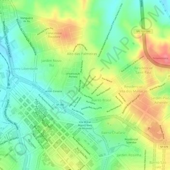
Name: Praça Amazonas topographic map, elevation, terrain.
Average elevation: 1,929 ft
Minimum elevation: 1,808 ft
Maximum elevation: 2,077 ft
Thank you for supporting this site ❤️
Make a donation
Make a donation
Gear up for your next adventure:
As an Amazon Associate, this site earns from qualifying purchases at no extra cost to you.
Other topographic maps
Click on a map to view its topography, its elevation and its terrain.
Centro Histórico da Cidade de Itu
Brasil > São Paulo > Região Metropolitana de Sorocaba > Itu
Average elevation: 1,916 ft
Parque Nossa Senhora da Candelária
Brasil > São Paulo > Região Metropolitana de Sorocaba > Itu
Average elevation: 1,877 ft