
Thank you for supporting this site ❤️
Make a donation
Make a donation
Gear up for your next adventure:
As an Amazon Associate, this site earns from qualifying purchases at no extra cost to you.
Ahornis topographic map
Click on the map to display elevation.
Thank you for supporting this site ❤️
Make a donation
Make a donation
Gear up for your next adventure:
As an Amazon Associate, this site earns from qualifying purchases at no extra cost to you.
About this map
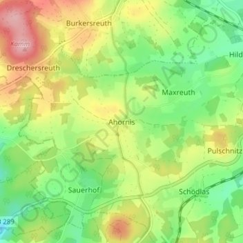
Name: Ahornis topographic map, elevation, terrain.
Location: Ahornis, Münchberg, Landkreis Hof, Bayern, 95233, Deutschland (50.17593 11.67485 50.21593 11.71485)
Average elevation: 2,018 ft
Minimum elevation: 1,798 ft
Maximum elevation: 2,320 ft
Thank you for supporting this site ❤️
Make a donation
Make a donation
Gear up for your next adventure:
As an Amazon Associate, this site earns from qualifying purchases at no extra cost to you.