
Make a donation
Gear up for your next adventure:
As an Amazon Associate, this site earns from qualifying purchases at no extra cost to you.
Yunchara topographic map
Click on the map to display elevation.
Make a donation
Gear up for your next adventure:
As an Amazon Associate, this site earns from qualifying purchases at no extra cost to you.
About this map
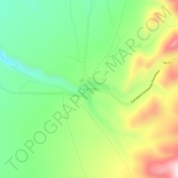
Name: Yunchara topographic map, elevation, terrain.
Average elevation: 11,860 ft
Minimum elevation: 11,194 ft
Maximum elevation: 12,877 ft
Make a donation
Gear up for your next adventure:
As an Amazon Associate, this site earns from qualifying purchases at no extra cost to you.
Other topographic maps
Click on a map to view its topography, its elevation and its terrain.
Arenales de Tajzara
Bolivia > Tarija > Provincia de José María Avilés > Municipio Yunchará > Copacabana
Average elevation: 12,103 ft
Laguna de Tajzara
Bolivia > Tarija > Provincia de José María Avilés > Municipio Yunchará
Average elevation: 11,959 ft
Carapari
Bolivia > Tarija > Provincia de José María Avilés > Municipio Yunchará > Carapari
Average elevation: 11,109 ft
Laguna de Tajzara
Bolivia > Tarija > Provincia de José María Avilés > Municipio Yunchará
El lago sin desagüe está ubicado en la parte sur de la meseta semiárida del altiplano bajo o subandino boliviano y está rodeado por picos montañosos que se elevan a una altitud de alrededor de 4.000 m s. n. m. El lago está a una altitud de 3.663 m y tiene una superficie de unas 434 hectáreas, pero esta…
Average elevation: 11,959 ft
Make a donation
Gear up for your next adventure:
As an Amazon Associate, this site earns from qualifying purchases at no extra cost to you.