
Thank you for supporting this site ❤️
Make a donation
Make a donation
Gear up for your next adventure:
As an Amazon Associate, this site earns from qualifying purchases at no extra cost to you.
Jiquilpan topographic map
Click on the map to display elevation.
Thank you for supporting this site ❤️
Make a donation
Make a donation
Gear up for your next adventure:
As an Amazon Associate, this site earns from qualifying purchases at no extra cost to you.
About this map
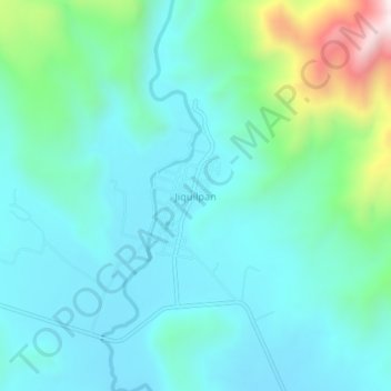
Name: Jiquilpan topographic map, elevation, terrain.
Location: Jiquilpan, San Gabriel, Jalisco, 49705, Mexico (19.75977 -103.79677 19.79977 -103.75677)
Average elevation: 4,636 ft
Minimum elevation: 4,177 ft
Maximum elevation: 6,522 ft
Thank you for supporting this site ❤️
Make a donation
Make a donation
Gear up for your next adventure:
As an Amazon Associate, this site earns from qualifying purchases at no extra cost to you.