
Make a donation
Gear up for your next adventure:
As an Amazon Associate, this site earns from qualifying purchases at no extra cost to you.
Oedelem topographic map
Click on the map to display elevation.
Make a donation
Gear up for your next adventure:
As an Amazon Associate, this site earns from qualifying purchases at no extra cost to you.
Oedelem
Oedelem behoort tot Zandig Vlaanderen en het landschap wordt gekenmerkt door de cuesta van Oedelem-Zomergem, welke leidt tot een golvend landschap op 10 à 23 meter hoogte. De drempel van de kerk ligt op 18 meter hoogte. De bodem bestaat uit lemig zand. Er zijn enkele bossen te vinden ten oosten van Oedelem, namelijk het Koningsbos bij Oostveld en het domein van Kasteel De Wapenaer. Ten noorden van Oedelem ligt een bescheiden hoogte, Berg genaamd, van meer dan 23 meter. Beken lopen in westelijke richting, zoals Hellepoelbeek en Bergbeek.
Make a donation
Gear up for your next adventure:
As an Amazon Associate, this site earns from qualifying purchases at no extra cost to you.
About this map
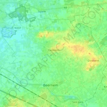
Name: Oedelem topographic map, elevation, terrain.
Location: Oedelem, Beernem, Brugge, West-Vlaanderen, Vlaanderen, België (51.13140 3.27286 51.20067 3.41096)
Average elevation: 30 ft
Minimum elevation: 3 ft
Maximum elevation: 79 ft
Make a donation
Gear up for your next adventure:
As an Amazon Associate, this site earns from qualifying purchases at no extra cost to you.
Other topographic maps
Click on a map to view its topography, its elevation and its terrain.