
Thank you for supporting this site ❤️
Make a donation
Make a donation
Gear up for your next adventure:
As an Amazon Associate, this site earns from qualifying purchases at no extra cost to you.
Antzora topographic map
Click on the map to display elevation.
Thank you for supporting this site ❤️
Make a donation
Make a donation
Gear up for your next adventure:
As an Amazon Associate, this site earns from qualifying purchases at no extra cost to you.
About this map
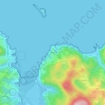
Name: Antzora topographic map, elevation, terrain.
Location: Antzora, Ibarrangelu, Vizcaya, País Vasco, 48360, España (43.38927 -2.69767 43.42927 -2.65767)
Average elevation: 167 ft
Minimum elevation: -13 ft
Maximum elevation: 1,093 ft
Thank you for supporting this site ❤️
Make a donation
Make a donation
Gear up for your next adventure:
As an Amazon Associate, this site earns from qualifying purchases at no extra cost to you.