
Make a donation
Gear up for your next adventure:
As an Amazon Associate, this site earns from qualifying purchases at no extra cost to you.
Orion Charter Township topographic map
Click on the map to display elevation.
Make a donation
Gear up for your next adventure:
As an Amazon Associate, this site earns from qualifying purchases at no extra cost to you.
About this map
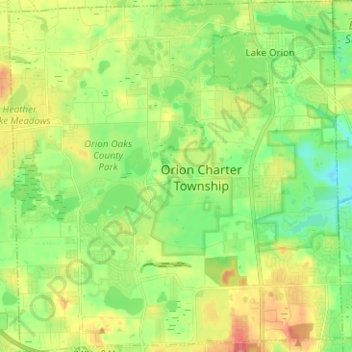
Name: Orion Charter Township topographic map, elevation, terrain.
Average elevation: 1,004 ft
Minimum elevation: 889 ft
Maximum elevation: 1,188 ft
Oakland County trails, hiking, mountain biking, running and outdoor activities
Make a donation
Gear up for your next adventure:
As an Amazon Associate, this site earns from qualifying purchases at no extra cost to you.
Other topographic maps
Click on a map to view its topography, its elevation and its terrain.
Veterans Park
United States > Michigan > Oakland County > Highland Charter Township
Average elevation: 1,017 ft
Waterbury Lake
United States > Michigan > Oakland County > Highland Charter Township
Average elevation: 1,010 ft
Davisburg
United States > Michigan > Oakland County > Springfield Charter Township
Average elevation: 1,014 ft
Make a donation
Gear up for your next adventure:
As an Amazon Associate, this site earns from qualifying purchases at no extra cost to you.
Round Lake
United States > Michigan > Oakland County > Orion Charter Township
Average elevation: 994 ft
Hickory Ridge
United States > Michigan > Oakland County > Highland Charter Township
Average elevation: 1,070 ft
Make a donation
Gear up for your next adventure:
As an Amazon Associate, this site earns from qualifying purchases at no extra cost to you.
Seven Harbors
United States > Michigan > Oakland County > Highland Charter Township
Average elevation: 1,030 ft
Carpenter Lake Nature Preserve
United States > Michigan > Oakland County > Southfield
Average elevation: 679 ft
Wood Creek Farms
United States > Michigan > Oakland County > Farmington Hills > Wood Creek Farms
Average elevation: 804 ft
Make a donation
Gear up for your next adventure:
As an Amazon Associate, this site earns from qualifying purchases at no extra cost to you.
Depot Park
United States > Michigan > Oakland County > Village of Clarkston
Average elevation: 1,010 ft