
Thank you for supporting this site ❤️
Make a donation
Make a donation
Gear up for your next adventure:
As an Amazon Associate, this site earns from qualifying purchases at no extra cost to you.
Polac topographic map
Click on the map to display elevation.
Thank you for supporting this site ❤️
Make a donation
Make a donation
Gear up for your next adventure:
As an Amazon Associate, this site earns from qualifying purchases at no extra cost to you.
About this map
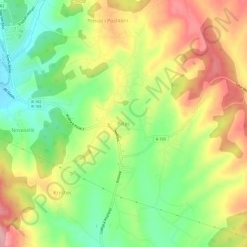
Name: Polac topographic map, elevation, terrain.
Location: Polac, Municipality of Skënderaj / Srbica, 41000, Kosovo (42.71204 20.80222 42.75204 20.84222)
Average elevation: 2,178 ft
Minimum elevation: 1,946 ft
Maximum elevation: 2,431 ft
Thank you for supporting this site ❤️
Make a donation
Make a donation
Gear up for your next adventure:
As an Amazon Associate, this site earns from qualifying purchases at no extra cost to you.