
Thank you for supporting this site ❤️
Make a donation
Make a donation
Gear up for your next adventure:
As an Amazon Associate, this site earns from qualifying purchases at no extra cost to you.
Drasco topographic map
Click on the map to display elevation.
Thank you for supporting this site ❤️
Make a donation
Make a donation
Gear up for your next adventure:
As an Amazon Associate, this site earns from qualifying purchases at no extra cost to you.
About this map
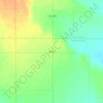
Name: Drasco topographic map, elevation, terrain.
Location: Drasco, Runnels County, Texas, 79622, United States (32.05705 -100.00781 32.09705 -99.96781)
Average elevation: 2,005 ft
Minimum elevation: 1,946 ft
Maximum elevation: 2,073 ft
Runnels County trails, hiking, mountain biking, running and outdoor activities
Thank you for supporting this site ❤️
Make a donation
Make a donation
Gear up for your next adventure:
As an Amazon Associate, this site earns from qualifying purchases at no extra cost to you.