
Make a donation
Gear up for your next adventure:
As an Amazon Associate, this site earns from qualifying purchases at no extra cost to you.
IHDP Colony(2) topographic map
Click on the map to display elevation.
Make a donation
Gear up for your next adventure:
As an Amazon Associate, this site earns from qualifying purchases at no extra cost to you.
About this map
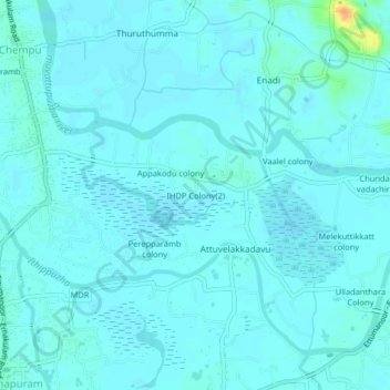
Name: IHDP Colony(2) topographic map, elevation, terrain.
Location: IHDP Colony(2), Vaikom, Kottayam, Kerala, 686608, India (9.77200 76.39526 9.81200 76.43526)
Average elevation: 13 ft
Minimum elevation: -3 ft
Maximum elevation: 118 ft
Make a donation
Gear up for your next adventure:
As an Amazon Associate, this site earns from qualifying purchases at no extra cost to you.
Other topographic maps
Click on a map to view its topography, its elevation and its terrain.
Make a donation
Gear up for your next adventure:
As an Amazon Associate, this site earns from qualifying purchases at no extra cost to you.
Arakkulam
India > Kerala > Vaikom > Thalayolaparambu > Chundangakari vadachira colony
Average elevation: 20 ft