Geolocate

La Isabel topographic map

Click on the map to display elevation.

About this map

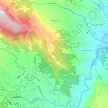
Name: La Isabel topographic map, elevation, terrain.

Location: La Isabel, Turrialba, Cartago, 30511, Costa Rica (9.90124 -83.68657 9.95469 -83.63387)

Average elevation: 2,310 ft

Minimum elevation: 1,398 ft

Maximum elevation: 4,068 ft

Other topographic maps

Click on a map to view its topography, its elevation and its terrain.

San Bosco

Costa Rica > Turrialba > Tuis

Average elevation: 2,822 ft

Grano de Oro

Costa Rica > Turrialba > Chirripó

Average elevation: 3,698 ft

Cerro Chirripó

Costa Rica > Turrialba > Chirripó

Average elevation: 11,808 ft

Gear up for your next adventure:

🦶Hiking Gaiters - Keep debris and water out of your boots
🧢Outdoor Hiking Hat - Sun protection hat for outdoor explorers
📖Nature Tracking Books - Learn to track wildlife and terrain
👓Polarized Sunglasses - Outdoor sunglasses for glare reduction
🪶Camping Sleeping Pad - Comfortable sleeping pad for backpacking

As an Amazon Associate, this site earns from qualifying purchases at no extra cost to you.