Geolocate

Felix topographic map

Click on the map to display elevation.

About this map

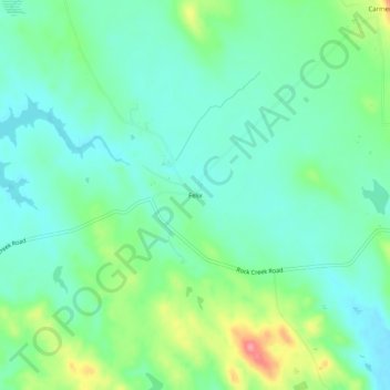
Name: Felix topographic map, elevation, terrain.

Location: Felix, Calaveras County, California, United States (38.00826 -120.73576 38.04826 -120.69576)

Average elevation: 1,145 ft

Minimum elevation: 1,056 ft

Maximum elevation: 1,375 ft

Calaveras County trails, hiking, mountain biking, running and outdoor activities

Gear up for your next adventure:

📶Satellite Messenger - Communication device off‑grid
🌐World Map Poster - Decorative world maps with topographic info
🌡️Portable Weather Meter - Track weather conditions on the trail
🔪Outdoor Multitools - Essential survival tools for gear repair and field use
🚁Photography Drones - Capture stunning aerial views of landforms and topography

As an Amazon Associate, this site earns from qualifying purchases at no extra cost to you.