
Make a donation
Gear up for your next adventure:
As an Amazon Associate, this site earns from qualifying purchases at no extra cost to you.
Muriel topographic map
Click on the map to display elevation.
Make a donation
Gear up for your next adventure:
As an Amazon Associate, this site earns from qualifying purchases at no extra cost to you.
Muriel
La localidad está situada en las últimas estribaciones de la sierra de Ayllón, en la margen derecha del río Sorbe. El pueblo está ubicado en un ensanchamiento del valle, protegido por las laderas de este, orientado al sur como muchos otros pueblos serranos. Está a una altitud de 870 m sobre el nivel del mar.
Make a donation
Gear up for your next adventure:
As an Amazon Associate, this site earns from qualifying purchases at no extra cost to you.
About this map
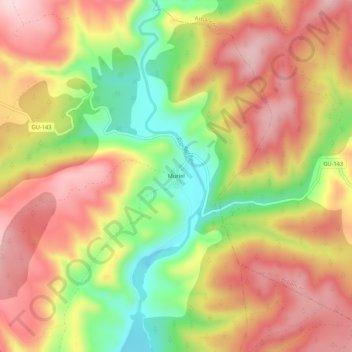
Name: Muriel topographic map, elevation, terrain.
Average elevation: 3,219 ft
Minimum elevation: 2,713 ft
Maximum elevation: 3,612 ft
Make a donation
Gear up for your next adventure:
As an Amazon Associate, this site earns from qualifying purchases at no extra cost to you.
Other topographic maps
Click on a map to view its topography, its elevation and its terrain.