
Thank you for supporting this site ❤️
Make a donation
Make a donation
Gear up for your next adventure:
As an Amazon Associate, this site earns from qualifying purchases at no extra cost to you.
Lebon Régis topographic map
Click on the map to display elevation.
Thank you for supporting this site ❤️
Make a donation
Make a donation
Gear up for your next adventure:
As an Amazon Associate, this site earns from qualifying purchases at no extra cost to you.
Lebon Régis
Localiza-se a uma latitude 26º55'44" sul e a uma longitude 50º41'43" oeste, estando a uma altitude de 980 metros. Sua população é estimada em 12 331 habitantes. Possui uma área de 990,74 km².
Thank you for supporting this site ❤️
Make a donation
Make a donation
Gear up for your next adventure:
As an Amazon Associate, this site earns from qualifying purchases at no extra cost to you.
About this map
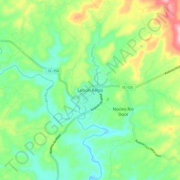
Name: Lebon Régis topographic map, elevation, terrain.
Average elevation: 3,386 ft
Minimum elevation: 3,094 ft
Maximum elevation: 3,999 ft
Thank you for supporting this site ❤️
Make a donation
Make a donation
Gear up for your next adventure:
As an Amazon Associate, this site earns from qualifying purchases at no extra cost to you.