
Make a donation
Gear up for your next adventure:
As an Amazon Associate, this site earns from qualifying purchases at no extra cost to you.
Barreda topographic map
Click on the map to display elevation.
Make a donation
Gear up for your next adventure:
As an Amazon Associate, this site earns from qualifying purchases at no extra cost to you.
Barreda
Barreda es una localidad del municipio de Torrelavega (Cantabria, España). Es el núcleo situado más al norte del término, a 2,2 kilómetros de la capital y 20 metros de altitud sobre el nivel del mar. El código postal de Barreda es el 39300. En esta localidad se encuentra el matadero comarcal.
Make a donation
Gear up for your next adventure:
As an Amazon Associate, this site earns from qualifying purchases at no extra cost to you.
About this map
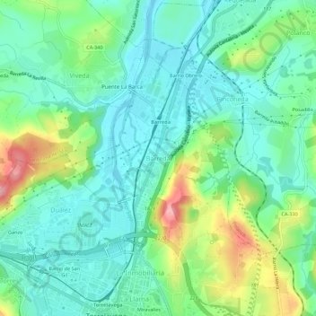
Name: Barreda topographic map, elevation, terrain.
Location: Barreda, Torrelavega, Besaya, Cantabria, 39300, España (43.34872 -4.06245 43.38872 -4.02245)
Average elevation: 125 ft
Minimum elevation: -10 ft
Maximum elevation: 430 ft
Make a donation
Gear up for your next adventure:
As an Amazon Associate, this site earns from qualifying purchases at no extra cost to you.