
Make a donation
Gear up for your next adventure:
As an Amazon Associate, this site earns from qualifying purchases at no extra cost to you.
Vallorbe topographic map
Click on the map to display elevation.
Make a donation
Gear up for your next adventure:
As an Amazon Associate, this site earns from qualifying purchases at no extra cost to you.
Vallorbe
L'altitude du territoire communal varie entre 610 mètres dans les gorges de l'Orbe et 1 480 mètres à la Dent de Vaulion; le centre du village est à 750 mètres.
Make a donation
Gear up for your next adventure:
As an Amazon Associate, this site earns from qualifying purchases at no extra cost to you.
About this map
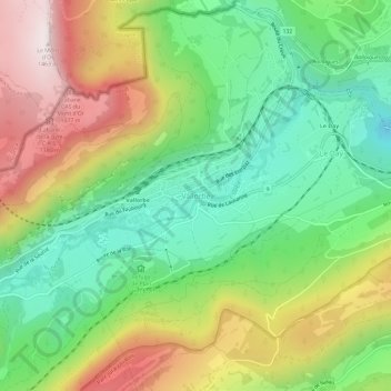
Name: Vallorbe topographic map, elevation, terrain.
Location: Vallorbe, District du Jura-Nord vaudois, Vaud, 1337, Suisse (46.69201 6.35923 46.73201 6.39923)
Average elevation: 3,199 ft
Minimum elevation: 2,126 ft
Maximum elevation: 4,780 ft
Make a donation
Gear up for your next adventure:
As an Amazon Associate, this site earns from qualifying purchases at no extra cost to you.