
Make a donation
Gear up for your next adventure:
As an Amazon Associate, this site earns from qualifying purchases at no extra cost to you.
Le Quartier topographic map
Click on the map to display elevation.
Make a donation
Gear up for your next adventure:
As an Amazon Associate, this site earns from qualifying purchases at no extra cost to you.
About this map
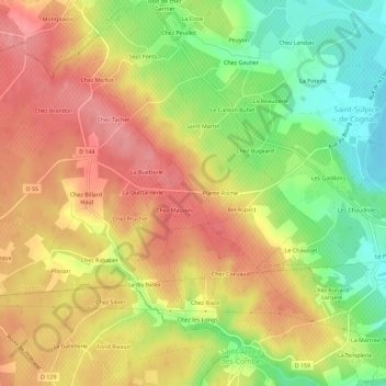
Name: Le Quartier topographic map, elevation, terrain.
Average elevation: 207 ft
Minimum elevation: 26 ft
Maximum elevation: 351 ft
Make a donation
Gear up for your next adventure:
As an Amazon Associate, this site earns from qualifying purchases at no extra cost to you.
Other topographic maps
Click on a map to view its topography, its elevation and its terrain.
Cherves-Richemont
France > Nouvelle-Aquitaine > Charente > Val-de-Cognac
La moitié nord de la commune est occupée par la plaine du pays bas, d'une altitude moyenne de 25 m et 10 m dans ses parties les plus basses.
Average elevation: 82 ft
Saint-Sulpice-de-Cognac
France > Nouvelle-Aquitaine > Charente > Val-de-Cognac
Hormis le tiers nord-est de la commune, le relief est assez vallonné et relativement haut. Le point culminant est à une altitude de 104 m, situé à 2 km à l'ouest du bourg, près de chez Tachet. Le point le plus bas est à 10 m, situé en limite sud-est le long de l'Antenne. Le bourg, situé au bord de…
Average elevation: 171 ft