
Make a donation
Gear up for your next adventure:
As an Amazon Associate, this site earns from qualifying purchases at no extra cost to you.
Wörth am Main topographic map
Click on the map to display elevation.
Make a donation
Gear up for your next adventure:
As an Amazon Associate, this site earns from qualifying purchases at no extra cost to you.
Wörth am Main
Der topographisch höchste Punkt der Stadtgemarkung befindet sich mit 398 m ü. NHN am Nordhang des Schabelsberges, südwestlich von Wörth, der niedrigste liegt im Main auf 116,5 m ü. NHN.
Make a donation
Gear up for your next adventure:
As an Amazon Associate, this site earns from qualifying purchases at no extra cost to you.
About this map
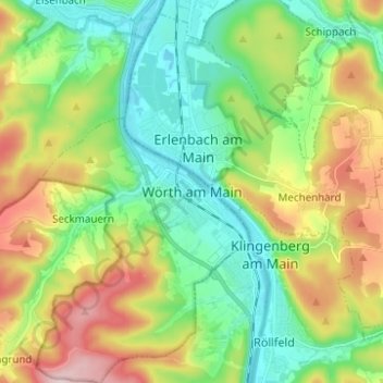
Name: Wörth am Main topographic map, elevation, terrain.
Location: Wörth am Main, Landkreis Miltenberg, Bayern, 63939, Deutschland (49.75551 9.11746 49.83551 9.19746)
Average elevation: 709 ft
Minimum elevation: 377 ft
Maximum elevation: 1,325 ft
Make a donation
Gear up for your next adventure:
As an Amazon Associate, this site earns from qualifying purchases at no extra cost to you.