
Thank you for supporting this site ❤️
Make a donation
Make a donation
Gear up for your next adventure:
As an Amazon Associate, this site earns from qualifying purchases at no extra cost to you.
Fiumenero topographic map
Click on the map to display elevation.
Thank you for supporting this site ❤️
Make a donation
Make a donation
Gear up for your next adventure:
As an Amazon Associate, this site earns from qualifying purchases at no extra cost to you.
About this map
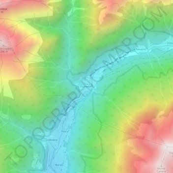
Name: Fiumenero topographic map, elevation, terrain.
Location: Fiumenero, Valbondione, Bergamo, Lombardia, 24020, Italia (46.00116 9.93725 46.04116 9.97725)
Average elevation: 4,318 ft
Minimum elevation: 2,359 ft
Maximum elevation: 7,605 ft
Thank you for supporting this site ❤️
Make a donation
Make a donation
Gear up for your next adventure:
As an Amazon Associate, this site earns from qualifying purchases at no extra cost to you.
Other topographic maps
Click on a map to view its topography, its elevation and its terrain.