Geolocate

Shigar topographic map

Click on the map to display elevation.

About this map

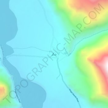
Name: Shigar topographic map, elevation, terrain.

Location: Shigar, Gilgit-Baltistan, Pakistan (35.40262 75.71711 35.44262 75.75711)

Average elevation: 7,999 ft

Minimum elevation: 7,241 ft

Maximum elevation: 11,273 ft

Gear up for your next adventure:

🪶Survival Guide Book - Expert advice for emergency preparedness
🛰️Handheld GPS Units - Professional satellite navigators for precise backcountry mapping
🥾Men's Hiking Boots - Durable, waterproof footwear for rugged terrain and steep inclines
🌎3D Topographic Globes - Raised relief globes for a tactile understanding of geography
🎒Outdoor Daypacks - Lightweight backpacks designed for carrying maps and essential gear

As an Amazon Associate, this site earns from qualifying purchases at no extra cost to you.