Geolocate

Cayabu topographic map

Click on the map to display elevation.

👉 Easily get elevation data in JSON, GeoTIFF and KML formats using Elevation API
Thank you for supporting this site ❤️
Make a donation

About this map

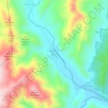
Name: Cayabu topographic map, elevation, terrain.

Location: Cayabu, Rizal, Calabarzon, Philippines (14.64160 121.32336 14.68160 121.36336)

Average elevation: 1,316 ft

Minimum elevation: 715 ft

Maximum elevation: 2,418 ft

Gear up for your next adventure:

Backpacking Tent - Lightweight and durable tent for multi‑day hikes
❄️Traction Cleats - Prevent slips on icy trails during winter hikes
🕶️Glacier Sunglasses - Side shields to protect eyes from high-altitude snow glare
🏕️Tent Footprint - Protect your tent base from wear
🧴Hand Sanitizer - Keep hands clean while hiking

As an Amazon Associate, this site earns from qualifying purchases at no extra cost to you.